The E-BARMM System
Expanded Bangsamoro Advanced Road Mapping and Management (E-BARMM) System is an online repository of MPW-BARMM projects. It was first conceptualized and created under the leadership of Regional Secretary Emil K. Sadain, with support from ARMM Regional Governor Hon. Mujiv Hataman.
Enhanced by Secretary Don Mustapha Loong, the system has grown through collaboration with the eight District Engineering Offices, focusing on project data validation via geotagged photos, RouteShoot app, and drone footage.
With the 2019 ARMM to BARMM transition, the system was relaunched by Secretaries Sadain and Loong, Chief Minister Hon. Ahod B. Ebrahim, MPW Minister Archt. Eduard U. Guerra, and other officials. E-BARMM continues to promote transparency and accountability in the ministry's project monitoring.
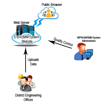
The general process of how E-BARMM works is shown.

Transparency and efficiency in project monitoring are the core goals of E-BARMM. However, challenges remain, such as logistical limitations in BASULTA (Basilan, Sulu, Tawi-Tawi) and IT capability gaps among DEOs responsible for data upload and processing.